Hamilton Silver District, Eureka, Nevada, USA

CSE:
HAMR
$
OTCID:
HAMRF
$
The Eliza Silver Project - (100% Owned - no NSR)
Location Map
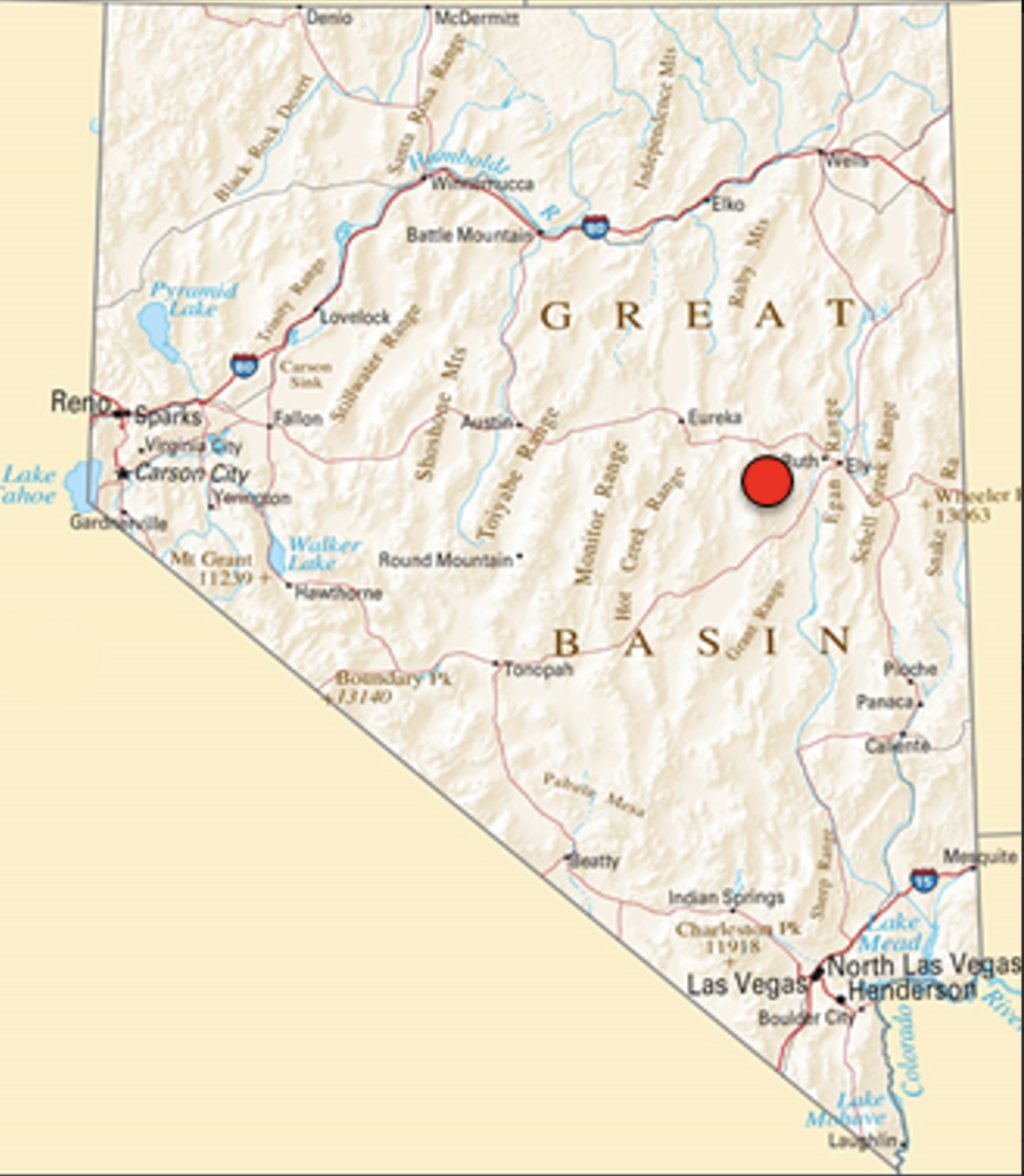
PROJECT OVERVIEW
The Eliza Silver Project is a 5.52km2 land package, which includes the past-producing California Mine Patent claim, and is located along strike of the Hamilton Mining District, Nevada’s highest-grade silver district, which produced 40 million (M) ounces (oz) silver with grades up to 25,000 grams per tonne (g/t) between 1876-1890.
Information gained from a detailed geologic map indicate that Eliza and the Hamilton District contain high-grade Ag mineralization hosted by the same formation; however, no significant work or drilling has been done on the project in over half a century.

Exploration
Assay results from an initial 2021 sampling program confirmed the existence of a well-developed silver-rich mineral system, which also shows enrichments in copper (Cu), lead (Pb) and zinc (Zn), suggesting the potential for the existence of a blind copper porphyry.
Recent samples include:
- PN662703: 1290 g/t Ag
- PN662717: 1180 g/t Ag; 7.70% Cu; 11.00% Pb; 13.40% Zn
- PN662715: 632 g/t Ag; 2.2% Cu; 1.49% Pb; 0.55% Zn
The Company significantly expanded mineralized footprint through 2022 soil sampling, identifying four primary target areas and plans to further evaluate the project in 2026.
The Company completed a property wide geophysics program in 2023 and has applied for a Plan of Operations permit to commence drilling in 2026.

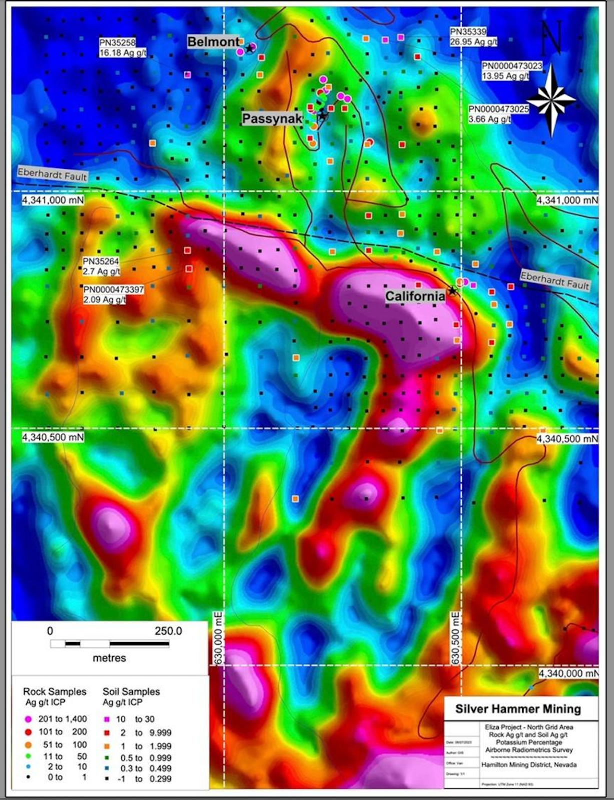
Eliza Geophysics 2023
Eliza Project Survey Technical Highlights
The geodetic system used for the Eliza geophysical survey was WGS 84 in UTM Zone 11N. A total of 360-line km were flown with a helicopter over the property. The survey was flown at 25 m line spacing on a heading of 090°/270°, while tie lines were flown at 250 m line spacing on a heading of 000°/180°.
Preliminary radiometric modeling shows strong correlation with field observations including the placement of the Eberhardt Fault, a major truncating (290° azimuth) fault that dissects the Hamilton Vein systems. The Belmont and Passynak zones are seen as radiometric highs that extend along a (010°) structural orientation (refer to Figure below:)
Airborne Radiometric Survey Results). Other anomalous radiometric highs have been identified along the same (010°) orientation indicating potential off-sets and extensions of mineralization south of the Eberhardt Fault.In total, the mineralized systems identified to date exhibit strong silver and base metal mineralization, visual structural control (010°) and now magnetic and radiometric anomalies which will assist the Company design new drill targets.
Geophysics Map